
Imagine capturing an entire building, a crime scene, or a fragile historical artifact in perfect 3D detail without ever touching it. That capability exists today through laser scanning technology. At its core, a laser scanner measures distance using light by firing rapid laser pulses, detecting their reflections, and calculating travel time or phase shift. These measurements generate millions of precise 3D points per second, forming a digital twin of the real world used across engineering, construction, forensics, and heritage preservation.
So how does a laser scanner work? It combines physics, optics, and advanced computing to turn light into spatial data. The process begins with a laser beam steered across a scene using mirrors or prisms. When the beam hits a surface, part of it bounces back to the scanner. Using the known speed of light, the system calculates how far the light traveled while high-precision sensors record the beam is horizontal and vertical angles. Together, these values define a single 3D point in space. Repeating this millions of times creates a complete, highly accurate 3D model of any environment.
Core Principle: Light Measures Distance
Laser scanning relies on LiDAR, which stands for Light Detection and Ranging. This remote sensing method uses focused laser light to map the physical world with much higher resolution than radar, which uses radio waves. The end goal of every laser scanner is to create a point cloud, a massive collection of individual x, y, z coordinates representing surfaces in a scanned scene.
Generate a 3D Point Cloud
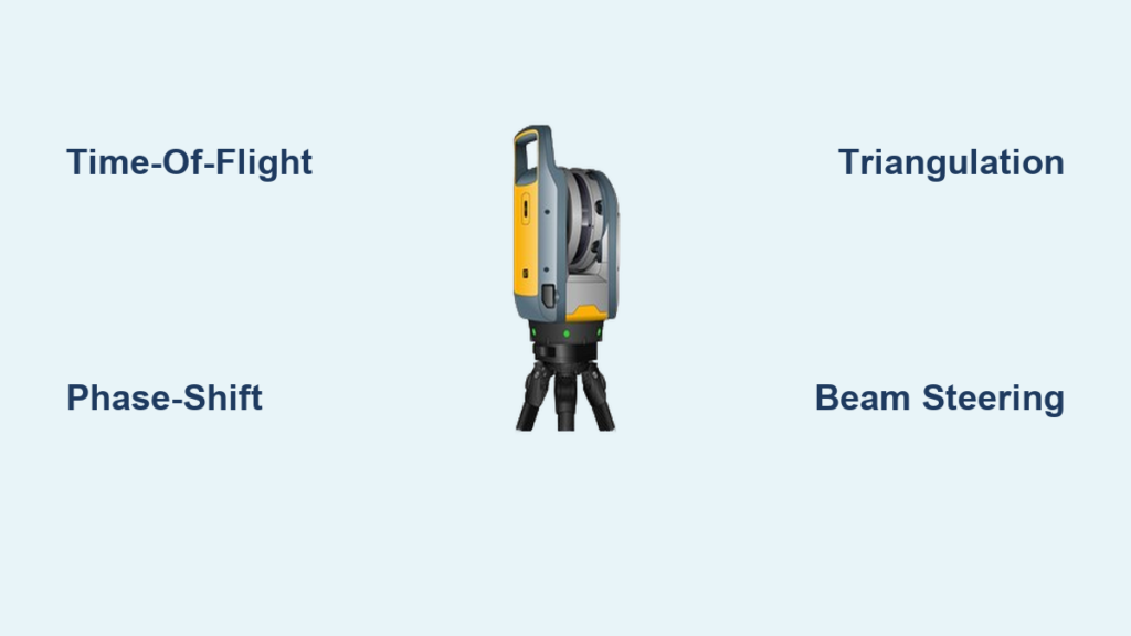
Each point captures the exact location where a laser pulse reflected off a surface. Modern scanners can collect up to 2 million points per second, building detailed models in minutes. The Leica RTC360 exemplifies this capability, capturing 2 million points per second with 2 to 4 millimeter accuracy, making it ideal for large construction sites or complex industrial plants.
These points are not just spatial coordinates. Many systems also record intensity, which helps identify materials by how strong the return signal was. RGB color from integrated cameras creates photorealistic models. Timestamps enable motion tracking or time-based analysis. Once processed, point clouds serve as the foundation for 3D BIM models, CAD drawings, digital twins, and virtual walkthroughs.
Three Key Measurements Per Point
To place each point accurately in 3D space, the scanner must know three things. First, distance to the surface measured via time-of-flight, phase-shift, or triangulation. Second, horizontal angle called azimuth, showing where the beam points left to right. Third, vertical angle called elevation, showing where it points up and down.
High-precision rotary encoders track these angles in real time. Combined with distance, they allow the scanner to compute the exact x, y, z position of every reflection. This triangulation of data, distance plus two angles, transforms a single moving laser dot into a flood of spatial intelligence.
Distance Measurement Methods
Not all laser scanners measure distance the same way. Three primary technologies are used, each suited to different ranges, accuracies, and applications.
Time-of-Flight: Long-Range Scanning
Time-of-flight scanners measure how long it takes for a laser pulse to travel to a target and back. The calculation uses the formula distance equals speed of light multiplied by time of flight, divided by two. Since light travels at 299,792,458 meters per second, even tiny time differences translate into measurable distances.
These scanners offer range up to 350 meters or more with typical accuracy of 2 to 4 millimeters. They can capture up to 2 million points per second, making them best for outdoor surveys, topographic mapping, and large industrial facilities. The Artec Ray II achieves 1.9 millimeter accuracy at 10 meters, perfect for scanning aircraft, ships, or wind turbines. Because ToF systems use pulsed lasers, they are less affected by ambient light and work well in sunlight.
Phase-Shift: High Precision at Medium Range
Instead of timing pulses, phase-shift scanners use continuous-wave lasers modulated at a specific frequency. They compare the phase difference between the outgoing and returning light waves. Higher frequencies yield better resolution, and these systems can achieve sub-millimeter accuracy.
These scanners typically work at ranges under 100 meters but can reach accuracy better than 1 millimeter. They excel in controlled environments like buildings or factories where high detail is needed without extreme range. However, they are more sensitive to multi-path interference from reflections and bright ambient light.
Triangulation: Short-Range, Ultra-High Accuracy
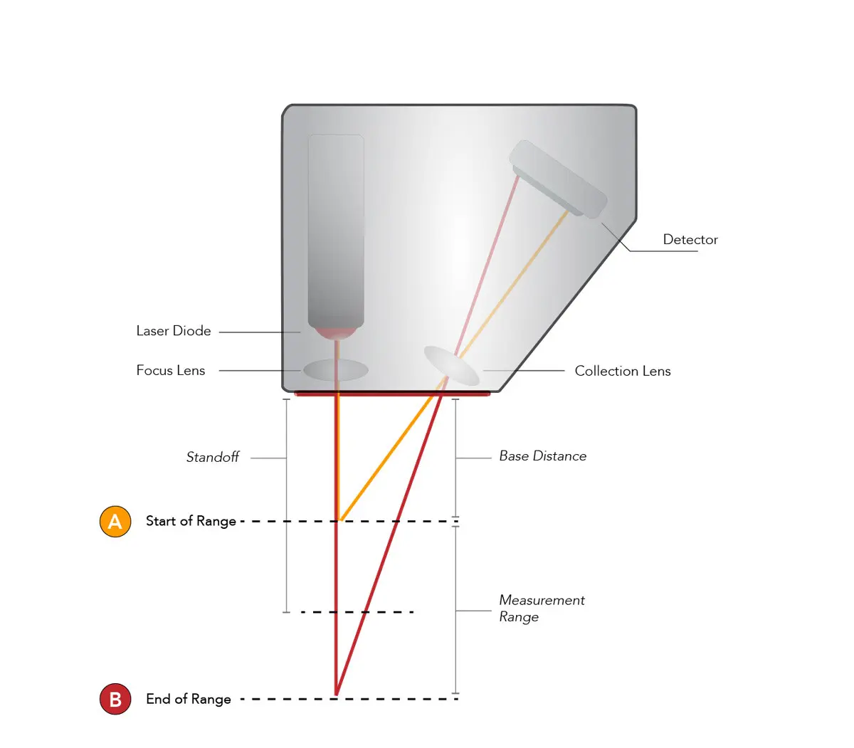
Triangulation scanners rely on geometry, forming a triangle between the laser source, the camera sensor, and the target point. The system knows the baseline distance between the laser and sensor. When the laser hits a surface, the reflected spot appears at a specific position in the camera is field of view. Using trigonometry, the scanner calculates distance based on the angle of observation.
These scanners work at ranges from 1 centimeter to 3 meters with accuracy as fine as 0.02 millimeters, or 20 micrometers. The Artec Point scanner delivers this level of precision, ideal for inspecting turbine blades or dental implants. Unlike ToF and phase-shift, triangulation loses accuracy with distance due to parallax error, so it is best for close-up, high-detail work.
Beam Steering: How the Laser Moves
A stationary laser only captures one point. To scan an entire scene, the beam must move rapidly across space through beam steering mechanisms.
Galvanometer Mirrors: Precision X-Y Scanning
Galvo scanners use small mirrors mounted on electromagnetic coils. When current flows through the coil, it generates a magnetic field that rotates the mirror with extreme precision. Two mirrors control horizontal and vertical axes, scanning patterns that cover up to plus or minus 20 degrees.
Galvos allow random-access scanning where the laser can jump instantly between points, unlike fixed-pattern systems. They are often paired with F-theta lenses to keep the beam focused across the entire scan field. However, there is a trade-off involving mechanical wear and thermal drift. If galvo motors overheat above 120 degrees Celsius, their magnets can permanently demagnetize.
Rotating Polygon Mirrors: High-Speed Line Scanning
These scanners use a multi-faceted mirror, hexagonal or octagonal, spinning at high speed. Each facet reflects the laser in a sweeping line. This method enables continuous, high-speed scanning ideal for production lines or aerial surveys.
However, it cannot do arbitrary patterns, only repetitive raster scans. The unidirectional scanning is very fast with line rates in the kHz range, but requires combination with motion or secondary mirrors for 2D coverage. Applications include laser printers, barcode readers, and high-speed LIDAR.
MEMS Microscanners: Compact and Portable
Micro-Electro-Mechanical Systems use tiny silicon mirrors that tilt electronically. They are millimeters in size and built using semiconductor fabrication techniques. This technology is key to making laser scanning portable and affordable.
MEMS scanners fit in handheld or mobile scanners with tiny size and low power consumption. They are used in pico projectors, smartphone LiDAR, and portable 3D scanners. The limitations include smaller angular range and lower durability compared to galvos.
Advanced Steering Technologies
Beyond mirrors, newer methods steer lasers without large moving parts, enabling faster and more reliable scanning.
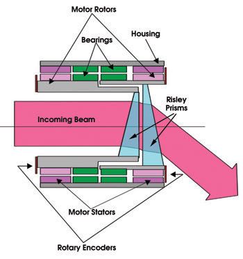
Risley Prisms: Steering Without Mirrors
Two rotating prisms bend the laser beam as they turn. By adjusting their relative angles, the beam can be directed within a cone-shaped field. This enables smooth, continuous beam motion without mirror oscillation.
There are no reflective surfaces, reducing alignment issues. Applications include aerospace, missile guidance, and space docking systems.
Acousto-Optic Deflectors: No Moving Parts
AODs use sound waves in a crystal like tellurium dioxide to create a moving diffraction grating. Changing the RF frequency changes the deflection angle. They offer MHz-range response, which is ultra-fast, and true random-access capability to jump between any points instantly.
However, AODs have small apertures under 2.5 millimeters and limited angular range under 3 degrees, restricting beam size and coverage. Applications include optical trapping, high-speed microscopy, and laser cooling.
Phased Array Scanning: Future of Solid-State LiDAR
Inspired by radar, phased arrays use multiple laser emitters with controlled phase delays to steer the beam electronically. This could revolutionize scanning by making systems smaller, faster, and more reliable.
There are no moving parts, making systems more durable and compact. This is emerging technology using VCSELs, and it has potential for self-driving cars, drones, and consumer devices.
Data Capture and Sensor Integration
Modern laser scanners do not just measure distance. They enrich data with color, orientation, and geolocation.
Add Color with Panoramic Cameras
Many scanners include 360-degree HD cameras that capture photos synchronized with the point cloud. Each point gets RGB values, creating photorealistic 3D models. The Leica RTC360 takes a full-color panoramic image in 60 seconds. Colorized point clouds make it easier to identify materials, labels, and structural details.
Track Movement with IMUs and Visual Inertia
Inertial Measurement Units detect orientation and motion. When you move a scanner between positions, IMUs help align scans automatically. Visual inertia uses onboard cameras to match features between scans, reducing the need for physical targets and speeding up field workflow. You can walk through a building and scan continuously with software stitching everything together.
Georeference with GPS
Outdoor scanners, especially airborne or mobile ones, integrate GNSS or GPS to tie data to real-world coordinates. This is essential for topographic maps, road surveys, and GIS systems. Without GPS, point clouds are accurate locally but not tied to Earth is coordinate system.
From Scan to Usable Model
Raw point clouds are just the beginning. To be useful, they must be processed into structured models.
Overcome Line-of-Sight Limits
Laser scanners only see what is in direct view. To capture all sides of a building or machine, you need multiple scan positions. Place the scanner in 3 to 5 locations around the object using overlapping areas to align scans. More overlap means better registration accuracy.
Register Scans Accurately
Combining multiple scans is called registration. Target-based registration uses spherical or checkerboard targets in the scene. The scanner detects them and uses known geometry to align scans, which is highly accurate and ideal for precision work. Targetless registration uses software like Iterative Closest Point to match overlapping geometry. It is faster with no targets needed but works best with rich surface detail. Combining both methods provides speed and accuracy.
Generate Final Deliverables
Once registered, point clouds convert into practical formats. BIM models at various LOD levels serve construction documentation. CAD drawings in 2D plans or 3D models support engineering work. Mesh models enable 3D printing or VR experiences. Digital twins facilitate facility management. Virtual tours allow remote collaboration. After the 2019 Notre Dame fire, laser scans taken years earlier guided the entire restoration effort.
Applications Across Industries

Laser scanning is transforming how we document, design, and preserve across many fields.
Capture As-Built Conditions
In construction, laser scanners replace tape measures and manual surveys. Teams scan existing buildings before renovation, compare actual versus design for BIM validation, and detect clashes before installation. A full hospital scan that once took weeks now takes days.
Reverse Engineer Legacy Parts
Manufacturers use scanners to recreate old or undocumented components. They capture worn turbine blades, molds, or custom fixtures and convert them to CAD for re-manufacturing. With triangulation scanners, they achieve micron-level accuracy. Aerospace firms feed scan data directly into CNC machines for adaptive machining.
Document Crime and Accident Scenes
Forensic teams scan crash sites and crime scenes in under 20 minutes. They preserve evidence digitally and reconstruct events later in 3D while minimizing road closures and site disruption. Courts accept scanned data as evidence, which is more reliable than photos or sketches.
Preserve Cultural Heritage
Museums and archaeologists scan artifacts and monuments non-invasively. No contact is needed, which is safe for fragile items. They create digital archives for future generations and enable virtual access to restricted sites. The Notre Dame pre-fire scan enabled accurate reconstruction after the blaze.
Monitor Industrial Assets
Oil rigs, power plants, and factories use scanning for pipeline routing and retrofit planning, safety zone modeling, and predictive maintenance through AI analysis. Teams scan hazardous areas remotely instead of sending personnel, improving safety.
Performance Limits and Challenges
Despite its power, laser scanning has real-world constraints.
Avoid Surface Reflectivity Issues
Not all surfaces reflect laser light well. Dark, matte surfaces absorb light and create weak returns. Shiny or mirrored surfaces cause specular reflections. Transparent materials like glass or water let light pass through. Use scanning targets, adjust exposure, or apply matte spray temporarily to overcome these issues.
Manage Ambient Light Interference
Bright sunlight can overwhelm phase-shift scanners. Use time-of-flight systems outdoors, scan during low-light hours like dawn or dusk, or shield the scanner if possible.
Handle Massive Data Volumes
A single project can generate hundreds of gigabytes of point cloud data. This requires powerful computers with 32 or more GB RAM and SSD storage. Use cloud processing to offload work and filter noise or downsample when detail is not needed. Only scan at high resolution when necessary to save time and storage.
Control Heat and Distortion
Fast scanning generates heat, especially in galvo systems. Double the scan angle produces four times more heat. Double the frequency produces 16 times more heat. Above 120 degrees Celsius, galvo magnets can fail permanently. Reduce speed, allow cooling breaks, and optimize scan paths to prevent damage.
Future of Laser Scanning
The technology is evolving fast, driven by AI, automation, and solid-state designs.
AI Automates Point Cloud Analysis
Machine learning now identifies walls, doors, pipes, and furniture in scans. It detects defects in manufactured parts and structural changes over time. The next step is real-time anomaly detection during scanning.
AR/VR Enables Immersive Review
Stakeholders can walk through digital twins in VR headsets. Teams review designs before construction, train workers in virtual plants, and collaborate remotely across continents.
Solid-State Scanners on the Horizon
VCSEL-based phased arrays could eliminate moving parts entirely. They are more durable, smaller, and cheaper, making them ideal for consumer devices and autonomous vehicles. Within 5 to 10 years, solid-state LiDAR may dominate mobile and drone platforms.
Cloud-Based Workflows
Processing no longer requires expensive local hardware. Teams upload scans to the cloud and get models back in hours, sharing with worldwide teams instantly. Scan today, model tomorrow is becoming the standard.
Key Takeaways for Understanding Laser Scanners
Laser scanning turns light into knowledge by measuring how laser beams bounce off the world to create precise 3D models at unprecedented speed. Whether restoring a cathedral, designing a factory, or solving a crime, the answer to how does a laser scanner work lies in the elegant fusion of physics, optics, and computing. The three core measurement methods, time-of-flight, phase-shift, and triangulation, each serve different ranges and accuracy needs. Beam steering mechanisms like galvos, polygons, and MEMS determine how quickly and precisely the laser maps a scene. As the technology evolves becoming faster, smarter, and more accessible it will continue to redefine what is possible in digital documentation and spatial analysis.
Frequently Asked Questions About Laser Scanners
How does a laser scanner measure distance?
A laser scanner measures distance using one of three methods. Time-of-flight scanners calculate how long a laser pulse takes to travel to a surface and bounce back. Phase-shift scanners compare the phase difference between outgoing and returning light waves. Triangulation scanners use geometric relationships between the laser, sensor, and target point. Each method produces precise distance measurements that combine with angle data to create 3D coordinates.
What is a point cloud in laser scanning?
A point cloud is a massive collection of individual x, y, z coordinates representing the surfaces in a scanned scene. Each point captures where a laser pulse reflected off a surface. Modern scanners generate up to 2 million points per second. These points form a detailed digital replica of the scanned environment that can be processed into 3D models, BIM files, or CAD drawings.
What industries use laser scanners?
Laser scanning is used across many industries. Construction and architecture use it for as-built documentation and BIM validation. Engineering and manufacturing use it for reverse engineering and quality control. Forensic teams use it to document crime scenes and accident sites. Heritage preservation teams scan historical buildings and artifacts. Oil, gas, and energy companies scan facilities for safety planning. Healthcare uses it for medical imaging and dental applications.
What are the main types of laser scanners?
The three main types are time-of-flight, phase-shift, and triangulation scanners. Time-of-flight scanners work best for long ranges up to 350 meters, ideal for outdoor and large-scale surveys. Phase-shift scanners offer high precision at medium ranges under 100 meters, perfect for detailed indoor work. Triangulation scanners provide ultra-high accuracy at short ranges under 3 meters, used for inspection and reverse engineering.
What are the limitations of laser scanning?
Laser scanners have several limitations. They require line-of-sight to surfaces, so multiple scan positions are needed. Dark, shiny, or transparent surfaces can produce weak or distorted returns. Bright sunlight affects phase-shift scanners. Data volumes can reach hundreds of gigabytes, requiring powerful computers. Heat buildup in galvo systems can cause permanent damage if temperatures exceed 120 degrees Celsius.